
Price based on lowest available cruise only fare for double occupancy. Subject to change at any time.
Silversea's Millennium Class luxury cruise ships Silver Shadow and Silver Whisper offer you freedom and space to design your day. Silver Shadow retains Silversea's essence – spacious suites and superior service – paired with a lively cosmopolitan atmosphere and enhanced amenities. Energise body and mind in the upgraded spa and fitness centre. Savour fine wines and French gastronomy in La Dame and enjoy authentic Italian cuisine in La Terrazza, endless ocean views from The Grill and internationally-inspired The Restaurant. From delectable dining to relaxation in ultra-luxury, cruising has never felt so good.
Cruise ID: 26673
Setting sail on Silversea promises peace of mind from start to finish. That means no worrying about tipping the butlers or staff. Our crew-to-guest ratio of almost 1:1 ensures flawless service from pole to pole, but with us, you never have to think about who should get a tip, how much you should give and when. It's all included! We believe that not having to deal with tipping helps make your luxury cruise even more special and stress-free. And that is worth every penny.
| Date | Time | Price * | Booking |
|---|---|---|---|
| 04 January 2026 | 19:00 | €6,265 | Call us to book |
| 11 January 2026 | 19:00 | €6,386 | Call us to book |
| 19 February 2026 | 19:00 | €6,145 | Call us to book |
* Price based on lowest available cruise only fare for double occupancy. Subject to change at any time.
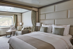
A quiet sanctuary. The sitting area of the Vista Suite has plenty of room to relax. Large picture windows frame panoramic ocean views. The perfect backdrop for breakfast in bed.
One bedroom: 27 sq.m.
Essentials
Characteristics
Furniture
Media & Communication
Onboard Services
Amenities
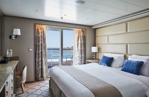
The name Owner's Suite says it all. A stylish apartment. Prestigious and classic. For those who seek the superlative level of space, comfort and service on board. Available as a one-bedroom configuration or as two-bedrooms (as illustrated) by adjoining with a Vista Suite.
One bedroom: 85 sq.m. including veranda
Two bedroom: 117 sq.m. including veranda
Please note that the 3rd guest will sleep on a comfortable sofa bed in the reception area of the suite.
Essentials
Characteristics
Furniture
Media & Communication
Onboard Services
Amenities
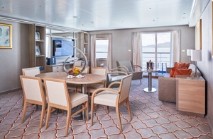
Expertly designed and exquisitely appointed. Ideal for entertaining friends while you cruise or enjoying a quiet dinner “at home”. Available as a one-bedroom configuration or as two-bedrooms (as illustrated) by adjoining with a Silversea Veranda Suite.
One bedroom: 87-101 sq.m. including veranda
Two bedroom: 133 sq.m. including veranda
Please note that the 3rd guest will sleep on a comfortable sofa bed in the reception area of the suite.
Essentials
Characteristics
Furniture
Media & Communication
Onboard Services
Amenities
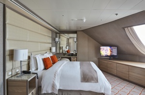
Stately describes the Royal Suite. Commanding and majestic. Perfect for entertaining. Enough living space to roam. The pinnacle of good living. Available as a one-bedroom configuration or as two-bedrooms (as illustrated) by adjoining with a Veranda Suite.
One bedroom: 90-94 sq.m. including veranda
Two bedroom: 126 sq.m. including veranda
Please note that the 3rd guest will sleep on a comfortable sofa bed in the reception area of the suite.
Essentials
Characteristics
Furniture
Media & Communication
Onboard Services
Amenities
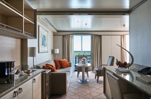
Stylish and sophisticated. Separate dining and living rooms. Larger verandas. Situated midship. Perfection in design for comfortable living. Silver Suites accommodate three guests.
One bedroom: 61-65 sq.m. including veranda
Please note that the 3rd guest will sleep on a comfortable sofa bed in the reception area of the suite.
Essentials
Characteristics
Furniture
Media & Communication
Onboard Services
Amenities
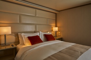
A mark of distinction. Sumptuous. Spacious. Rich textures and panoramic views surround you with distinguished luxury. An extravagant suite for an extravagant cruise.
One bedroom: 49 sq.m. including veranda
Please note that the 3rd guest will sleep on a comfortable sofa bed in the reception area of the suite.
Essentials
Characteristics
Furniture
Media & Communication
Onboard Services
Amenities
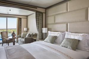
The Deluxe Veranda Suite offers a comfortable living space, close to the heart of the ship. With its preferred mid-ship location and all the comfort and attention to detail that you can expect aboard, the Deluxe Veranda Suite is the savvy traveller's paradise— both inside and out. Elegant décor, stunning marble bathroom and ample seating area, make this a cosy home away from home. But perhaps this suite's finest asset lies just outside, as floor-to-ceiling glass doors open onto a private veranda, making every sunset feel as if it is yours alone.
One bedroom: 32 sq.m. including veranda
Please note that the 3rd guest will sleep on a comfortable sofa bed in the reception area of the suite.
Essentials
Characteristics
Furniture
Media & Communication
Onboard Services
Amenities
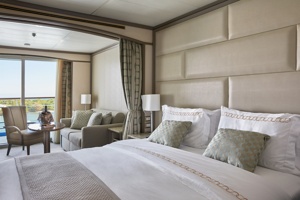
Located on the upper deck, and offering spectacular sunset views, the Superior Veranda Suite has all the comforts and luxury that you can expect aboard. A comfortable living space, attention to detail and a generous expanse of amenities, this stunning suite makes for a cosy home while on the seas. But perhaps this suite's finest asset lies just outside, as floor-to-ceiling glass doors open onto a private veranda, making every sunset feel as if it is yours alone.
One bedroom: 32 sq.m. including veranda
Wheelchair accessible suites: 535 and 537
Please note that the 3rd guest will sleep on a comfortable sofa bed in the reception area of the suite.
Essentials
Characteristics
Furniture
Media & Communication
Onboard Services
Amenities
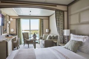
The Classic Veranda Suite provides generous living space for voyagers. Located lower bow, the Classic Veranda Suite offers all the comfort and attention to detail that you can expect aboard — both inside and out. A generous expanse of interior comforts — elegant décor, stunning marble bathroom and ample seating area, make this a cosy home away from home. But perhaps this suite's finest asset lies just outside, as floor-to-ceiling glass doors open onto a private veranda, making every sunset feel as if it is yours alone.
One bedroom: 32 sq.m. including veranda
Please note that the 3rd guest will sleep on a comfortable sofa bed in the reception area of the suite.
Essentials
Characteristics
Furniture
Media & Communication
Onboard Services
Amenities
Day 1 Philipsburg, Sint Maarten (Dutch part)
The capital of Dutch St. Maarten stretches about a mile (1½ km) along an isthmus between Great Bay and the Salt Pond and has five parallel streets. Most of the village's dozens of shops and restaurants are on Front Street, narrow and cobblestone, closest to Great Bay. It's generally congested when cruise ships are in port, because of its many duty-free shops and several casinos. Little lanes called steegjes connect Front Street with Back Street, which has fewer shops and considerably less congestion. Along the beach is a ½-mile-long (1-km-long) boardwalk with restaurants and several Wi-Fi hot spots.Wathey Square (pronounced watty) is in the heart of the village. Directly across from the square are the town hall and the courthouse, in a striking white building with cupola. The structure was built in 1793 and has served as the commander's home, a fire station, a jail, and a post office. The streets surrounding the square are lined with hotels, duty-free shops, restaurants, and cafés. The Captain Hodge Pier, just off the square, is a good spot to view Great Bay and the beach that stretches alongside.
Day 2 Saint John's, Antigua and Barbuda
With its superb beaches, historical attractions and beautiful coral reefs, Antigua provides a host of diversions. It is said that the island contains 365 beaches, one for every day of the year. Antigua maintains its traditional West Indian character, with gingerbread-house style architecture, calypso music and carnival festivities. St John's has been the administrative capital since the island's colonisation in 1632, and has been the seat of government since it gained independence in 1981. From the port you can explore the colourful Redcliffe district, with its restored wooden houses, and Heritage Quay with its shopping mall and craft shops. The city has some fine examples of Colonial architecture, including the twin-towered cathedral, built in 1845 and considered one of the finest church buildings in the Caribbean. All coaches in Antigua are operated by smaller vehicles, and commentary will be given by a driver/guide.
Day 3 Saint Thomas, U.S. Virgin Islands
If you fly to the 32-square-mile (83-square-km) island of St. Thomas, you land at its western end; if you arrive by cruise ship, you come into one of the world's most beautiful harbors. Either way, one of your first sights is the town of Charlotte Amalie. From the harbor you see an idyllic-looking village that spreads into the lower hills. If you were expecting a quiet hamlet with its inhabitants hanging out under palm trees, you've missed that era by about 300 years. Although other islands in the USVI developed plantation economies, St. Thomas cultivated its harbor, and it became a thriving seaport soon after it was settled by the Danish in the 1600s. The success of the naturally perfect harbor was enhanced by the fact that the Danes—who ruled St. Thomas with only a couple of short interruptions from 1666 to 1917—avoided involvement in some 100 years' worth of European wars. Denmark was the only European country with colonies in the Caribbean to stay neutral during the War of the Spanish Succession in the early 1700s. Thus, products of the Dutch, English, and French islands—sugar, cotton, and indigo—were traded through Charlotte Amalie, along with the regular shipments of slaves. When the Spanish wars ended, trade fell off, but by the end of the 1700s Europe was at war again, Denmark again remained neutral, and St. Thomas continued to prosper. Even into the 1800s, while the economies of St. Croix and St. John foundered with the market for sugarcane, St. Thomas's economy remained vigorous. This prosperity led to the development of shipyards, a well-organized banking system, and a large merchant class. In 1845 Charlotte Amalie had 101 large importing houses owned by the English, French, Germans, Haitians, Spaniards, Americans, Sephardim, and Danes. Charlotte Amalie is still one of the world's most active cruise-ship ports. On almost any day at least one and sometimes as many as eight cruise ships are tied to the docks or anchored outside the harbor. Gently rocking in the shadows of these giant floating hotels are just about every other kind of vessel imaginable: sleek sailing catamarans that will take you on a sunset cruise complete with rum punch and a Jimmy Buffett soundtrack, private megayachts for billionaires, and barnacle-bottom sloops—with laundry draped over the lifelines—that are home to world-cruising gypsies. Huge container ships pull up in Sub Base, west of the harbor, bringing in everything from breakfast cereals to tires. Anchored right along the waterfront are down-island barges that ply the waters between the Greater Antilles and the Leeward Islands, transporting goods such as refrigerators, VCRs, and disposable diapers. The waterfront road through Charlotte Amalie was once part of the harbor. Before it was filled in to build the highway, the beach came right up to the back door of the warehouses that now line the thoroughfare. Two hundred years ago those warehouses were filled with indigo, tobacco, and cotton. Today the stone buildings house silk, crystal, and diamonds. Exotic fragrances are still traded, but by island beauty queens in air-conditioned perfume palaces instead of through open market stalls. The pirates of old used St. Thomas as a base from which to raid merchant ships of every nation, though they were particularly fond of the gold- and silver-laden treasure ships heading to Spain. Pirates are still around, but today's versions use St. Thomas as a drop-off for their contraband: illegal immigrants and drugs. To explore outside Charlotte Amalie, rent a car or hire a taxi. Your rental car should come with a good map; if not, pick up the pocket-size "St. Thomas–St. John Road Map" at a tourist information center. Roads are marked with route numbers, but they're confusing and seem to switch numbers suddenly. Roads are also identified by signs bearing the St. Thomas–St. John Hotel and Tourism Association's mascot, Tommy the Starfish. More than 100 of these color-coded signs line the island's main routes. Orange signs trace the route from the airport to Red Hook, green signs identify the road from town to Magens Bay, Tommy's face on a yellow background points from Mafolie to Crown Bay through the north side, red signs lead from Smith Bay to Four Corners via Skyline Drive, and blue signs mark the route from the cruise-ship dock at Havensight to Red Hook. These color-coded routes are not marked on most visitor maps, however. Allow yourself a day to explore, especially if you want to stop to take pictures or to enjoy a light bite or refreshing swim. Most gas stations are on the island's more populated eastern end, so fill up before heading to the north side. And remember to drive on the left!
Day 4 Little Bay, Montserrat
Day 5 Castries, Saint Lucia
The typical image of a lush tropical paradise comes to life on the friendly island of St Lucia. Despite its small size – just 27 miles long and 14 miles wide – St Lucia is rich in natural splendour with dense emerald rainforest, banana plantations and orchards of coconut, mango and papaya trees. The twin peaks of Les Pitons, now a UNESCO World Heritage Site rise dramatically 2,000 feet into the sky and dominate the island. Look out for unusual birds with brilliant plumage such as the St Lucia parrot, see a surprising diversity of exotic flora and enjoy the warm hospitality of the islanders in the small villages and open-air markets. Please be aware that St Lucia is a small, mountainous island, with steep, winding and bumpy roads. Customers with back and neck problems should take this into consideration when booking an excursion.
Day 6 Mayreau Island, Saint Vincent and the Grenadines
The small island of Mayreau, just one and 1/2 square miles in area (3.9 square kilometres) is the smallest inhabited island of The Grenadines, and is part of the independent state of St.Vincent in the eastern Caribbean Sea. Two of the best known islands in The Grenadines are Mustique and Bequia, the second largest island in this group. The Grenadine Islands are strung out in a gentle sweep between St.Vincent and Grenada. Most visitors to Mayreau arrive from cruise ships, on the regular ferry, or by yacht. There are no proper roads on the island, only a few vehicles, no airport and only a single unnamed village. Mayreau and the neighboring Tobago Cays are very popular for divers and snorkellers. Saline Bay, on the west coast of the island, has a wonderful broad beach and a few local vendors selling T-shirts and local craft. A climb up the road to the hilltop village on the island provides breathtaking views across Mayreau, Canouan, the Tobago Cays and Carriacou.
Day 7 Îles des Saintes, Guadeloupe
This small group of islands lies opposite the western part of Guadeloupe. They were discovered in November 1493 by Columbus, who named them Los Santos. French settlers established themselves in 1648 and changed the name to Iles des Saintes, commonly known as Les Saintes. Since then the islands have been closely connected with Guadeloupe. Until a recent influx of tourism, Les Saintes were among the Caribbean's most unspoiled destinations. Only two of the eight islands are inhabited: Terre-de-Bas and Terre-de-Haut. The latter is known for its impressive Fort Napoleon built in the early 19th century to replace an earlier 17th-century fort. From its vantage point there are fine views of the many tiny islets scattered in the bay and across to Guadeloupe. Terre-de-Haut is the main island of Les Saintes, with steeply scarped hills, scenic valleys, hidden coves and beautiful beaches. Its main settlement consists of a charming village of red-roofed houses situated along a curving bay. A number of small boutiques and gift shops invite browsing. Quaint cafés and restaurants offer food and drink. To the east of the village lies Grande Anse, a fine sand beach. Most of the attractions on this small island can be seen on foot. With just a few vehicles on the island, there are no organized tours possible. Time ashore here is at your leisure.
Day 8 Philipsburg, Sint Maarten (Dutch part)
The capital of Dutch St. Maarten stretches about a mile (1½ km) along an isthmus between Great Bay and the Salt Pond and has five parallel streets. Most of the village's dozens of shops and restaurants are on Front Street, narrow and cobblestone, closest to Great Bay. It's generally congested when cruise ships are in port, because of its many duty-free shops and several casinos. Little lanes called steegjes connect Front Street with Back Street, which has fewer shops and considerably less congestion. Along the beach is a ½-mile-long (1-km-long) boardwalk with restaurants and several Wi-Fi hot spots.Wathey Square (pronounced watty) is in the heart of the village. Directly across from the square are the town hall and the courthouse, in a striking white building with cupola. The structure was built in 1793 and has served as the commander's home, a fire station, a jail, and a post office. The streets surrounding the square are lined with hotels, duty-free shops, restaurants, and cafés. The Captain Hodge Pier, just off the square, is a good spot to view Great Bay and the beach that stretches alongside.
The Department of Foreign Affairs has up-to-date advice for Irish citizens on staying safe and healthy abroad. For more security, local laws, health, passport and visa information see https://www.dfa.ie/travel/travel-advice/ and follow dfatravelwise