Price based on lowest available cruise only fare for double occupancy. Subject to change at any time.
A major upgrade in December 2018 saw Silver Wind looking better than ever. A second refurbishment in November 2021 saw her benefitting from a strengthened ice-class hull and made her one of the most adaptable ships in our fleet. Still timelessly elegant, still luxuriously relaxed, Silver Wind's improved cruising versatility means she can whizz from Polar Regions to iconic ports with fluid ease. Whether you want to get up close and personal to penguins in Antarctica or laze on the golden sands of the Caribbean, get ready for a wealth of diverse destination experiences aboard Silver Wind.
Cruise ID: 27904
Setting sail on Silversea promises peace of mind from start to finish. That means no worrying about tipping the butlers or staff. Our crew-to-guest ratio of almost 1:1 ensures flawless service from pole to pole, but with us, you never have to think about who should get a tip, how much you should give and when. It's all included! We believe that not having to deal with tipping helps make your luxury cruise even more special and stress-free. And that is worth every penny.
| Date | Time | Price * | Booking |
|---|---|---|---|
| 31 October 2024 | 19:00 | €11,687 | Call us to book |
* Price based on lowest available cruise only fare for double occupancy. Subject to change at any time.
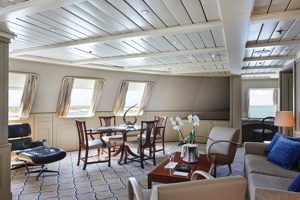
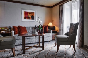
The name says it all. A stylish apartment. Prestigious and classic. For those who seek the superlative level of space, comfort and service on board. The Owner's Suite is available as a one-bedroom configuration or as two bedrooms (as illustrated) by adjoining with a Vista Suite so you can enjoy your luxury cruise in style.
One bedroom: 55 sq.m. including veranda
Two bedroom: 77 sq.m. including veranda
Images and suite plans are intended as a general reference. Features, materials, finishes and layout maybe different than shown.
Please note that the 3rd guest will sleep on a comfortable sofa bed in the reception area of the suite.
Essentials
Characteristics
Furniture
Media & Communication
Onboard Services
Amenities
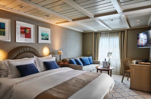
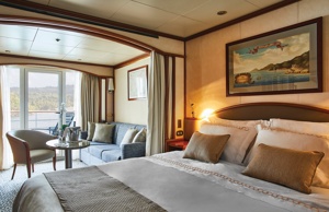
Expertly designed and exquisitely appointed. The Grand Suite on the Silver Wind ideal for entertaining friends or enjoying a quiet dinner “at home”. Available as a one-bedroom configuration or as two bedroom by adjoining with a Veranda Suite.
One bedroom: 95 sq.m. including veranda
Two bedroom: 122 sq.m. including veranda
Images and suite plans are intended as a general reference. Features, materials, finishes and layout maybe different than shown.
Please note that the 3rd guest will sleep on a comfortable sofa bed in the reception area of the suite.
Essentials
Characteristics
Furniture
Media & Communication
Onboard Services
Amenities
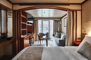
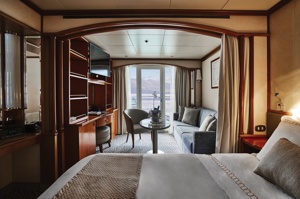
Stately. Commanding and majestic. Perfect for entertaining. The Royal suite lives up to its name. Enough living space to roam. The pinnacle of good living. Available as a one-bedroom configuration or as two bedroom by adjoining with a Veranda Suite.
One bedroom: 69 sq.m. including veranda
Two bedroom: 96 sq.m. including veranda
Images and suite plans are intended as a general reference. Features, materials, finishes and layout maybe different than shown.
Please note that the 3rd guest will sleep on a comfortable sofa bed in the reception area of the suite.
Essentials
Characteristics
Furniture
Media & Communication
Onboard Services
Amenities
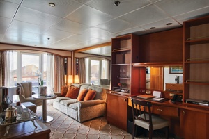
For those wanting more space, Silver Suites are ideal. Stylish and sophisticated. Separate dining and living rooms. Larger verandas. Situated midship on the Silver Wind. Perfection in design for comfortable living. Silver Suites accommodate three guests.
One bedroom: 48 sq.m. including veranda
Images and suite plans are intended as a general reference. Features, materials, finishes and layout maybe different than shown.
Please note that the 3rd guest will sleep on a comfortable sofa bed in the reception area of the suite.
Essentials
Characteristics
Furniture
Media & Communication
Onboard Services
Amenities
A mark of distinction. Sumptuous. Spacious. Rich textures and panoramic views surround you with distinguished luxury. The perfect summary of The Medallion Suite offered by the world's best cruise line.
One bedroom: 41 sq.m. including veranda
Suite 741: 667 sq.ft / 62 sq.m. with French balcony, separate dining area and full-size bath.
Suites 801-804 only: with Veranda
Images and suite plans are intended as a general reference. Features, materials, finishes and layout maybe different than shown.
Please note that the 3rd guest will sleep on a comfortable sofa bed in the reception area of the suite.
Essentials
Characteristics
Furniture
Media & Communication
Onboard Services
Amenities
The Deluxe Veranda Suite offers unbeatable views. A Silversea signature. Spacious and welcoming. Floor-to-ceiling glass doors open onto a furnished private teak veranda. Each spectacular sunset feels like it is yours alone. The Deluxe Veranda Suite offers a preferred central location with identical accommodation to a Veranda Suite. No top cruise line would be complete without such a luxury.
One bedroom: 27 sq.m. including veranda
Images and suite plans are intended as a general reference. Features, materials, finishes and layout maybe different than shown.
Please note that the 3rd guest will sleep on a comfortable sofa bed in the reception area of the suite.
Essentials
Characteristics
Furniture
Media & Communication
Onboard Services
Amenities
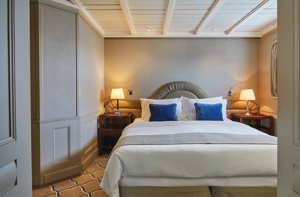
A Silversea signature, the Classic Veranda Suite is spacious and welcoming. Veranda suites offer floor-to-ceiling glass doors which open onto a furnished private teak veranda. Each spectacular sunset feels like it is yours alone. Some Classic Veranda Suites accommodate three guests. A must for the world's best cruise line.
One bedroom: 27 sq.m. including veranda
Images and suite plans are intended as a general reference. Features, materials, finishes and layout maybe different than shown.
Please note that the 3rd guest will sleep on a comfortable sofa bed in the reception area of the suite.
Essentials
Characteristics
Furniture
Media & Communication
Onboard Services
Amenities
A quiet sanctuary to escape to on your cruise. The sitting area has plenty of room to relax. Large picture windows frame panoramic ocean views. The perfect backdrop for breakfast in bed. Silver Wind Vista Suites accommodate three guests.
One bedroom: 22 sq.m.
Suite 738: 325 sq.ft. / 30 sq.m.
Wheelchair accessible suites: 445 and 447
Images and suite plans are intended as a general reference. Features, materials, finishes and layout maybe different than shown.
Please note that the 3rd guest will sleep on a comfortable sofa bed in the reception area of the suite.
Essentials
Characteristics
Furniture
Media & Communication
Onboard Services
Amenities
Day 1 Puntarenas, Costa Rica
This town is not on the Nicoya Peninsula, but rather on Costa Rica's mainland. It is best known as a cruise-ship port and launching pad for ferries heading southeast to the coast of the Nicoya Peninsula and for cruises sailing out on the Gulf of Nicoya. Puntarenas is also a major fishing port with a lively fish market. The town's reputation suffers from the unimpressive parts you see from your car as you roll through town on the way to the ferry dock. But the town has a lot of character off the main drag, thanks to its illustrious past as an affluent port town and principal vacation spot for San José's wealthy, who arrived by train in the last century. Once the port was moved and roads opened to other beaches, Puntarenas's economy crashed, but it's making a comeback. Sitting on a narrow spit of sand—punta de arenas literally means "point of sand"—that protrudes into the Gulf of Nicoya, the town boasts a beautifully groomed, wide Blue Flag beach with views of the Nicoya Peninsula and spectacular sunsets, along with a public swimming pool, the San Lucas Beach Club, and a marine-life museum. Ticos arrive by bus and car to enjoy the beach and stroll the Paseo de los Turistas, a beachfront promenade lined with tree-shaded concrete benches and seafood restaurants. Crowds of locals, called porteños, cruise by on bicycles, the town's most popular form of transport.
Day 2 Playa Panama, Costa Rica
Day 3 Punta Leona, Costa Rica
Day 4 Golfito, Costa Rica
Golfito, is situated along a small inlet of Golfo Dulce. This small port city is a narrow strip along Golfito Bay backed against steep green hills covered with pristine rainforest, with the Golfo Dulce seaward outside Golfito Bay. Surrounded by tropical rainforest, Golfito provides an ideal location to escape from your hectic schedule and enjoy some of the most beautiful beaches in Costa Rica with a stunning backdrop of verdant hills and lush rainforest. Follow a trail through the densely forested Golfito National Wildlife Refuge to observe rare flora and fauna, and emerge at a scenic outlook with views of the ocean, also the city has a variety of hotels and restaurants, many of which now provide free wireless Internet service for customers. Golfito was the main port on the South Pacific Coast of Costa Rica in the days when there was little except for the huge banana plantations. To help remedy the resulting economy decrease of the region, the government established a duty-free zone, support and impulse the touristic development.
Day 5 Cocos Island, Costa Rica
Cocos Island (Isla del Coco in Spanish) is an uninhabited island located off the shore of Costa Rica. It is a National & Marine Park and UNESCO World Heritage site and is surrounded by deep waters with counter-currents, offering excellent environments for many different species of fish. The beauty of Cocos has inspired tales of pirate treasure and the island was one of Jacques Cousteau's favorite places. Seabirds also favor Isla del Coco including Brown boobies, Red-footed Boobies and Great Frigatebirds. The three endemic land bird species call the island home; the Cocos Cuckoo, Cocos flycatcher, and Cocos finch.
Day 6 Cocos Island, Costa Rica
Cocos Island (Isla del Coco in Spanish) is an uninhabited island located off the shore of Costa Rica. It is a National & Marine Park and UNESCO World Heritage site and is surrounded by deep waters with counter-currents, offering excellent environments for many different species of fish. The beauty of Cocos has inspired tales of pirate treasure and the island was one of Jacques Cousteau's favorite places. Seabirds also favor Isla del Coco including Brown boobies, Red-footed Boobies and Great Frigatebirds. The three endemic land bird species call the island home; the Cocos Cuckoo, Cocos flycatcher, and Cocos finch.
Day 7 Cruising
Day 8 Puerto Lopez, Ecuador
Days 9-10 Cruising
Day 11 Callao, Peru
When people discuss great South American cities, Lima is often overlooked. But Peru's capital can hold its own against its neighbors. It has an oceanfront setting, colonial-era splendor, sophisticated dining, and nonstop nightlife.It's true that the city—clogged with traffic and choked with fumes—doesn't make a good first impression, especially since the airport is in an industrial neighborhood. But wander around the regal edifices surrounding the Plaza de Armas, among the gnarled olive trees of San Isidro's Parque El Olivar, or along the winding lanes in the coastal community of Barranco, and you'll find yourself charmed.In 1535 Francisco Pizarro found the perfect place for the capital of Spain's colonial empire. On a natural port, the so-called Ciudad de los Reyes (City of Kings) allowed Spain to ship home all the gold the conquistador plundered from the Inca. Lima served as the capital of Spain's South American empire for 300 years, and it's safe to say that no other colonial city enjoyed such power and prestige during this period.When Peru declared its independence from Spain in 1821, the declaration was read in the square that Pizarro had so carefully designed. Many of the colonial-era buildings around the Plaza de Armas are standing today. Walk a few blocks in any direction for churches and elegant houses that reveal just how wealthy this city once was. But the poor state of most buildings attests to the fact that the country's wealthy families have moved to neighborhoods to the south over the past century.The walls that surrounded the city were demolished in 1870, making way for unprecedented growth. A former hacienda became the graceful residential neighborhood of San Isidro. In the early 1920s the construction of tree-lined Avenida Arequipa heralded the development of neighborhoods such as bustling Miraflores and bohemian Barranco.Almost a third of the country's population of 29 million lives in the metropolitan area, many of them in relatively poor conos: newer neighborhoods on the outskirts of the city. Most residents of those neighborhoods moved there from mountain villages during the political violence and poverty that marked the 1980s and '90s, when crime increased dramatically. During the past decade the country has enjoyed peace and steady economic growth, which have been accompanied by many improvements and refurbishment in the city. Residents who used to steer clear of the historic center now stroll along its streets. And many travelers who once would have avoided the city altogether now plan to spend a day here and end up staying two or three.
Day 12 Paracas, Peru
The port city of Paracas is blessed with magnificent natural beauty and rich historical importance, offerings inviting beaches, ideal weather and pleasant scenery — a combination that draws visitors throughout the year. The shores of the Paracas Peninsula and waters of the bay teem with wildlife and have been declared a national reserve. Condors frequently can be seen gliding on the sea winds or perched on the cliffs; pink flamingos often rest here on their migratory flights. The complex interaction between wind and ocean, sun and land has transformed this region into a kind of lunarscape under an equatorial sun. Another reason for travellers to come to this area is its proximity to the famous and mysterious Nazca Lines. Visible from the air, these strange markings stretch for miles on a large barren plain and have bewildered archaeologists, historians and mathematicians since their discovery over a century ago. The earliest Andean people found shelter here. The Paracas culture was known for fine weavings in geometrical designs and vibrant colours, which have been preserved for thousands of years by the dry climate. Some of the finest examples are in museums in Lima. The town of Ica is Peru's finest wine centre, as well as home to the fiery brandy-derived beverage known as Pisco. The surrounding area features oases with springs considered to have medicinal cures. Pier Information The ship is scheduled to dock at Port of Paracas, about a 45-minute drive from Ica. There are no passenger facilities at the pier. Shopping Shopping opportunities are limited; some souvenirs can be found at the museum in Ica. A bottle of Peruvian Pisco (grape brandy) makes a nice memento. The local currency is the nuevo sol. Cuisine Seafood is highly recommended, however, we recommend you dine only in the hotel restaurants in Peru's southern region. Be sure to sample the national drink pisco sour and the area's excellent wines. Always drink bottled water and avoid ice cubes. Other Sites The Bay of Paracas is sheltered by the Paracas peninsula, noted as one of the best marine reserves in the world. This is also a popular resort area thanks to its beautiful bay, beaches and dependable warm weather. Facilities include swimming pools, tennis courts, miniature golf and a good restaurant. For those who are looking for a little adventure dune buggies are available. Local boat trips can be booked to the Ballestas Islands but be aware that commentary is given in Spanish. Private arrangements for independent sightseeing are limited in this port as cars have to come from Lima. Please submit your request to the Tour Office early in the cruise.
Day 13 Cruising
Day 14 Arica, Chile
Arica boasts that it is "the land of the eternal spring," but its temperate climate and beaches are not the only reason to visit this small city. Relax for an hour or two on the Plaza 21 de Mayo. Walk to the pier and watch the pelicans and sea lions trail the fishing boats as the afternoon's catch comes in. Walk to the top of the Morro and imagine battles of days gone by, or wonder at the magnitude of modern shipping as Chilean goods leave the port below by container ship.Arica is gaining notice for its great surfing conditions, and in 2009 hosted the Rusty Arica Pro Surf Challenge, a qualifying event to the world series of surf.
Day 15 Cruising
Day 16 Antofagasta, Chile
Situated between the ocean and the mountains of the Coastal Range is Chile's largest city of the northern region. Antofagasta's role as port for the exportation of nitrate began in 1866. In 1872, when silver was discovered, the first municipality was established. Today, Antofagasta is still the centre of nitrate and copper mining, as well as an important hub for rail traffic to La Paz, Bolivia, and Salta, Argentina. According to the treaty signed after the War of the Pacific, much of Bolivia's international commerce transits through Antofagasta. The area surrounding Antofagasta is renowned for having the highest solar intensity in the world. Its archaeological zones, desert and mountains make it a sought after place for travellers looking for unusual destinations. The city's landscaped plazas are a tribute to man's conquest over the desert. Plaza Colón boasts a landmark Westminster clock donated by the British residents; the design of the old Customs House is an odd combination of Spanish colonial and Swiss chalet-style architecture. The soil in the gardens along Avenida O'Higgins was brought from all over the world as ships' ballast, replaced by nitrate for their return voyages. Arriving by sea presents the best view of Antofagasta's unique setting between the ocean, the desert and the mountains – arguably the city's most impressive feature. Please Note: Due to the limited tourism infrastructure in this port, the buses and guides may not be up to Western standards but are the best available in this particular area. Local conditions may be challenging, therefore we urge flexibility and understanding as we visit these unique, and somewhat remote destinations. Pier Information The ship is scheduled to dock at the Port of Antofagasta, located about 2 miles (3 km) from the town centre. Taxis are not allowed inside the port. Shopping The major shopping area for local goods is found along the three-block pedestrian zone. A handicrafts market is located in the Plaza del Mercado, featuring articles made by artists in the High-Plateau area. Most shops open a 9:30 a.m. and close between 1:30 p.m. and 4:00 p.m. The local currency is the peso. Cuisine For good food with an excellent view, beach and swimming pool, the Hotel Antofagasta is worth a try. The Yacht Club is also noted for fine cuisine and a great view of the old harbour. Other Sites In addition to the attractions covered on the organized tour, sports enthusiasts will find a golf course with sand greens. Guests interested should check with the Shore Concierge Office on board well in advance for availability and reservations. Please bear in mind that mostly Spanish speaking visitors frequent this region; English is not widely spoken. Private arrangements for independent sightseeing may be requested through the Shore Concierge Office on board, subject to the availability of English-speaking guides. There are no sedans available, only vans.
Day 17 Isla Pan de Azúcar, Chile
The rugged shores of Isla Pan de Azucar (or Sugarloaf Island) are home to thousands of Humboldt Penguins. The penguins come to this arid island to breed and spend their days fishing, swimming and diving, as do many of the other birds found here. The waters around Isla Pan de Azucar also support Kelp Gulls, Blackish Oystercatchers, Peruvian Boobies, pelicans, sea lions and the reclusive South American marine otter.
Day 18 Coquimbo, Chile
The name Coquimbo is derived from a native Diaguita word meaning 'place of calm waters'. In fact, Charles Darwin had noted that the town was 'remarkable for nothing but its extreme quietness'. Since then, Coquimbo has developed into a bustling port and the region's major commercial and industrial centre from which minerals, fish products and fruits are exported. Used during the colonial period as a port for La Serena, Coquimbo attracted attention from English pirates, including Sir Francis Drake, who visited in 1578. Visitors enjoy strolling around the town, admiring some of the elaborate woodwork handcrafted on buildings by early British and American settlers. These wooden buildings are among Chile's most interesting historical structures. Out of town, the area offers some fine beaches in a desert-like setting. Coquimbo serves as a gateway to the popular resort town of La Serena and trips farther into the Elqui Valley, known as the production centre for Chile's national drink, pisco sour. The valley is also home to several international observatories that take advantage of the region's exceptional atmospheric conditions.
Day 19 Valparaiso, Chile
Valparaíso's dramatic topography—45 cerros, or hills, overlooking the ocean—requires the use of winding pathways and wooden ascensores (funiculars) to get up many of the grades. The slopes are covered by candy-color houses—there are almost no apartments in the city—most of which have exteriors of corrugated metal peeled from shipping containers decades ago. Valparaíso has served as Santiago's port for centuries. Before the Panama Canal opened, Valparaíso was the busiest port in South America. Harsh realities—changing trade routes, industrial decline—have diminished its importance, but it remains Chile's principal port. Most shops, banks, restaurants, bars, and other businesses cluster along the handful of streets called El Plan (the flat area) that are closest to the shoreline. Porteños (which means "the residents of the port") live in the surrounding hills in an undulating array of colorful abodes. At the top of any of the dozens of stairways, the paseos (promenades) have spectacular views; many are named after prominent Yugoslavian, Basque, and German immigrants. Neighborhoods are named for the hills they cover. With the jumble of power lines overhead and the hundreds of buses that slow down—but never completely stop—to pick up agile riders, it's hard to forget you're in a city. Still, walking is the best way to experience Valparaíso. Be careful where you step, though—locals aren't very conscientious about curbing their dogs.


The Department of Foreign Affairs has up-to-date advice for Irish citizens on staying safe and healthy abroad. For more security, local laws, health, passport and visa information see https://www.dfa.ie/travel/travel-advice/ and follow dfatravelwise